 |
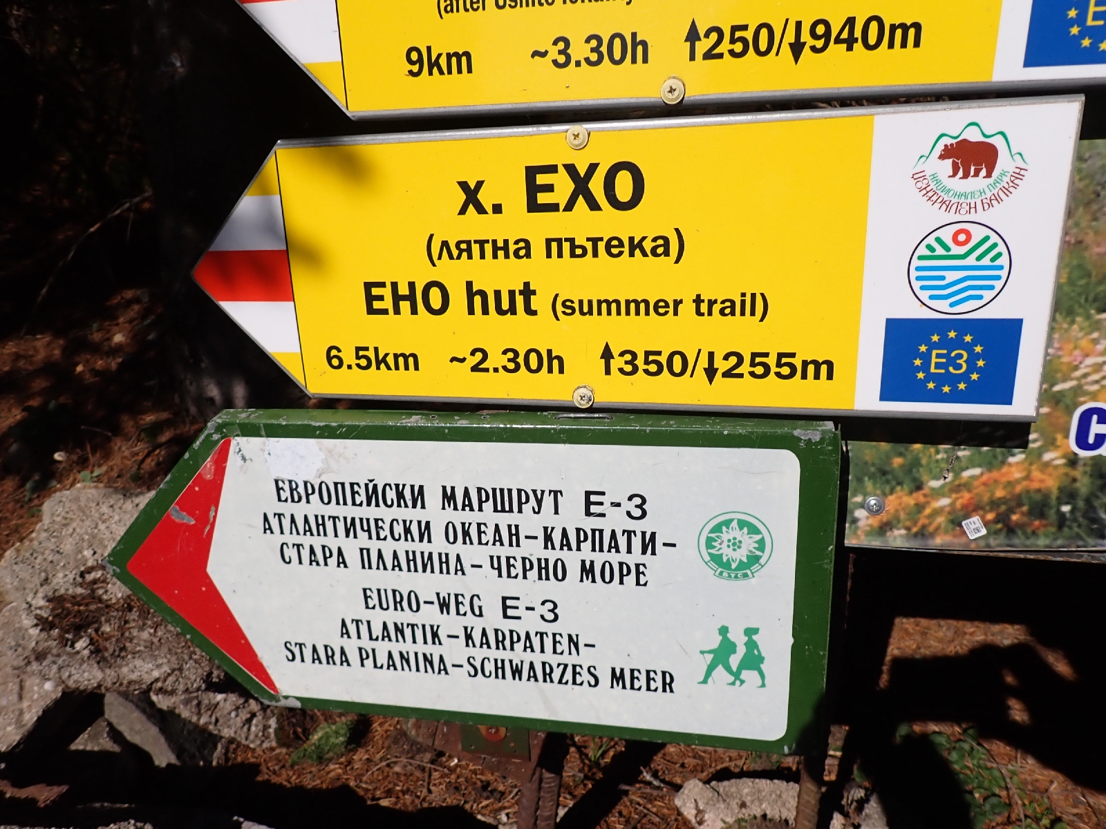
| Signs and waymarks. |
In the eastern third, the trail is mainly through deciduous woodland with beech forests being the most beautiful, some over 100 years old. There are open areas but for much of the way, trees hide the view. This third contains most of the villages and the one town (Kotel) the trail passes through. Most of the villages are grouped together, populated by people of a Turkish and Muslim heritage, and will be walked through in one day, others are partially abandoned. The route mainly follows forest tracks, but there are also path and road sections. In places the trail is overgrown, with brambles being most annoying, grabbing at you and your clothing. Accommodation is limited in this section outside of Kotel, and wild camping will need to be considered.
If you have limited time the middle third is undoubtedly the best. Here the trail climbs over open mountains above the trees with occasional rock outcrops to negotiate and classic ridge sections. Views are far reaching across Bulgaria. A little light scrambling is required on one day, with cables to assist, otherwise the paths require no technical skill. Bypass tracks at lower altitudes are available should the weather be poor. There are plenty of huts avoiding the need to carry a tent, the main trail passes through no villages but the huts can provide meals. The route mainly follows paths which often wind among rocks, blueberry bushes and creeping juniper.
The western third is a mixture. There are woods, high treeless ridges and a long valley section after the village of Gara Lakatnik (the only village on the route). Although there are a number of huts, they are not as plentiful as on the middle section and you may need to camp a night or two.
The huts on the route broadly fall into three types. The best are almost hotels where I had my own bedroom with ensuite facilities, while a bedside lamp might be missing and refinements lacking, they made for an enjoyable stay, especially after wild camping or more "rough and ready" huts. These included Dobrila, Himik, Partizanska Pesen and Proboinitsa "huts". At the lower end, huts had dormitory accommodation, shared toilets and limited washing facilities. The most basic was Botev Shelter with "hole in the floor" toilets some way outside the hut. Dormitory accommodation consisted of bunk beds rather than sleeping platforms, sheets and blankets were provided. In the middle of the range were large huts with many bedrooms containing two or three beds each that I would not expect to have to share. Toilets were in general down the corridor. Good value if a bit institutional. There were also unmanned shelters which might have sleeping platforms (and empty beer cans) but no toilets or other amenities. I preferred to camp rather than use them. All the manned huts had a "restaurant" area where you could sit in the warm even when not eating. At a hatch to the kitchen you ordered and received your food. You could also bring your own food. With two exceptions I found the hut keepers did not speak English, the odd word at best. Google Translate proved an essential App to communicate, remember to download the Bulgarian language so you can use it without a phone signal, although a surprising number of huts had WiFi. In general huts did not have on-line booking. I used Bulguides to book the huts, as in October when I travelled there might not have otherwise been anyone there. Even then two hut keepers forgot I was coming. Some hut keepers did not always appear to welcome a solo, English speaking traveller, maybe more trouble than I was worth, others were very welcoming! I was often the only person staying at the hut, being out of season, although on Friday and Saturday nights they were more busy. Friends might meet up in a hut with music and a selection of food to graze on (such chopped up sausage, cheese, tomatoes and cucumber which they would bring with them). A little rakya might be drunk and there would be endless conversation (what do people find to talk about?).
One key reason for staying at the huts was to get food. Between Kotel and Lakatnik, which is most of the Kom-Emine, there are no food shops, just a few places at road passes where you can buy chocolates and snacks. Consequently, eating at huts saves deviating off the hiking trail to buy provisions. Getting food at a hut could be a struggle. In the best cases there would be a menu on a whiteboard. Even though handwritten Google Translate made a good stab at translating such menus into English. In the worst case they ask you what you want, but you do not know what's available! If in doubt ask for soup (bean, chicken and pork belly soups seemed most common), shopska salad (like a Greek salad) and three meatballs (kofte, which are like small hamburgers). The meatballs are not served with anything so ask for bread, only a few places were offering chips. Shopska salad was not always available and I ended up with a cabbage and carrot salad a couple of times, good for me I am sure. In some cases they say what they have, implying there is nothing else. In the central region, popular huts are open for food at lunch time, so you can buy some bread and soup. If you persist you may be able to get lunch at other huts.

Waymarking was by a horizontal red stripe between two white stripes. It could be very comprehensive or it could be sporadic or totally absent. Do not confuse the red and white stripes with black and white ones, these are forester's markings. Blue, green and yellow and white stripes mark other paths. There were also direction signs of various vintages. For the higher ridge routes there are also alternatives which bypass them at a lower level for use in poor weather, these also link up with additional huts. Alternate routes for cyclists are available in places.
An English language guidebook is available and worth the money. I ordered mine from Bulguides. However, the stages it recommends are far too long on some days. I split these guidebook days into more manageable chunks. Although the guidebook has 20 daily stages I took 26 days including a rest day in Kotel, which was well worth it as it is an interesting town. Although you can buy paper maps I relied on my GPS, which I would recommend as it tells you where you are (make sure you have lots of spare batteries). I loaded a few gpx trails of the Kom-Emine onto my GPS, including from the waymarked trails website. There is a Kom-Emine website although the gpx track from this site failed to download for me. I loaded a digital map of Bulgaria I bought for my last trip in 2018 marked OFRM Geotrade.
I walked the route in October which risked snow, but I was lucky, it was unusually warm the year I completed it. Some frost in the mornings at higher altitudes but the sun soon warmed things up. Heavy rain made one day miserable, otherwise it was generally dry. The huts all seemed to have heating, if only from a big, wood burning stove. Walking in October I met fewer people than I would have in summer, and was alone with the hut keeper in a number of huts.
I found the Kom-Emine a tough trek, especially the eastern part, with some days being a bit of a slog. It was not helped by my bowel problems and general lack of appetite the first week. Maybe I could have planned it better, I was a bit complacent after completing the GR5 over the French Alps earlier in the summer. A few years ago I walked the E4 through the Rila and Pirin mountains in Bulgaria which was a better trip. Amazing scenery, a good guidebook, lots of huts and being in August, plenty of fellow hikers. One good thing about Bulgaria are the low prices compared with any other place in Europe.
Various lengths are quoted for the Kom-Emine, it depends on whether you follow any bad weather bypasses or other alternatives. 600 kilometres is a round figure, I actually walked 587 kilometres from Cap Emine to Kom Peak, but inevitably you need to walk a bit further to reach a road. After I finished I translated the certificate I had been given at the start of my walk at Villa Emona. It promised a free beer! The only catch was I would have to return to Emona to get it, great if you are walking in the opposite direction to me.
The start of my blog is here.


No comments:
Post a Comment