I will now be following the E4 route until the Djerdap dam where I hope to cross into Romania and continue on the E3 there. Although the E4 starts close to the border with Bulgaria I did not want to retrace my steps repeating the three or four kilometres that I covered yesterday. Instead I took a road north to join the E4 higher up, the same road as that followed by the Eurovelo 13 cycle route that follows the path of the iron curtain. It is a route I will meet again.
As I climbed the first ridge a succession of tractors passed me, they looked like they were off to collect trees that had been felled. Later it was just cars and beyond Smilovci, nothing at all. I diverted into the centre of the rustic village of Radejna as a collection of signs implied there maybe something there. Having walked to the centre I was still not sure what it was, everything was quiet aside from one barking dog, maybe there was some accommodation if you knew how to access it. The buildings made of wood and mud attracted my curiosity. They looked like a type of construction used in Britain a century or more ago. Possibly they were once used to store hay on the upper floor. I also spotted buildings with bricks made of mud and straw, patches of white "plaster" coating them falling away with age.

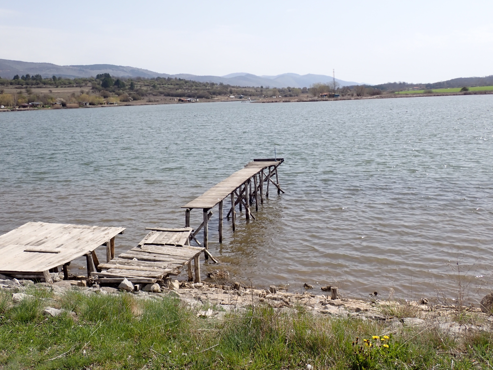
The road continued over a second ridge, I was walking against the grain of the land. Between this and the final ridge was a flat area with a lake beside which I rested on a convenient bench. People were fishing from the end of rickety jetties that poked out into the water. On the other side of the lake there were huts of contrasting appearances, presumably belonging to the fishermen.
At the edge of the village of Smilovci I saw a stork hunting for insects in the grass, earlier I heard the call of the cuckoo a sound of spring, and was that an eagle soaring in circles above the hillside? I was hoping for a Coke and chocolate at a village shop I had visited before when I walked this way. Sadly I was disappointed, it had closed permanently. I considered visiting the small Orthodox Church opposite but the wire wrapped around the gates put me off. It did not look as if it was much used.
There seemed to have been new signs erected since my last trip, one directed me to the Monastery of St Kirik and Jylita. It was written in both Serbian and Bulgarian Cyrillic characters, their alphabets differ by a few letters. A reminder that I was close to the Bulgarian border. Although the E4 bypasses the monastery (according to waymarkedtrails.org) it seemed a pity to miss it. A long climb up the third and highest ridge was required. On the way was a new viewing platform which gave an extensive view. At the monastery itself there were a couple of children visiting the church, kissing the icons and chatting with an older nun in her black habit, shorter than they were. I joined them in the church, unfortunately forgetting to cover my arms, so I went back out for my fleece and returned to view the many icons both on the iconostasis and hung on the walls. I left a few euros in a collecting plate and the nun offered me candle, which I declined, unsure whether it would help God hear my prayers.
A path runs up through low oak trees from behind the Monastery, the oaks were still leafless at this time of year but the hawthorns were bursting into green leaf. An earthy smell rose from the earth, warmed by the sun. Last time I walked this path I was poorly directed by a hiking map I had acquired, one of the few published in Serbia. I missed part of the path, stumbling along a steep slope among vegetation. This time, starting from the bottom it was easier, although once on the ridge prickly bushes did impede my progress. Higher up the bushes thinned out. The ground was covered with pieces of limestone among which there were pools of small blue flowers, probably grape hyacinths. Scorch marks suggested a wild fire had come through the area a year or two ago. Reaching the top I stood beneath a sky of Wedgewood blue, which faded to white haze on the distant, mountainous horizon.

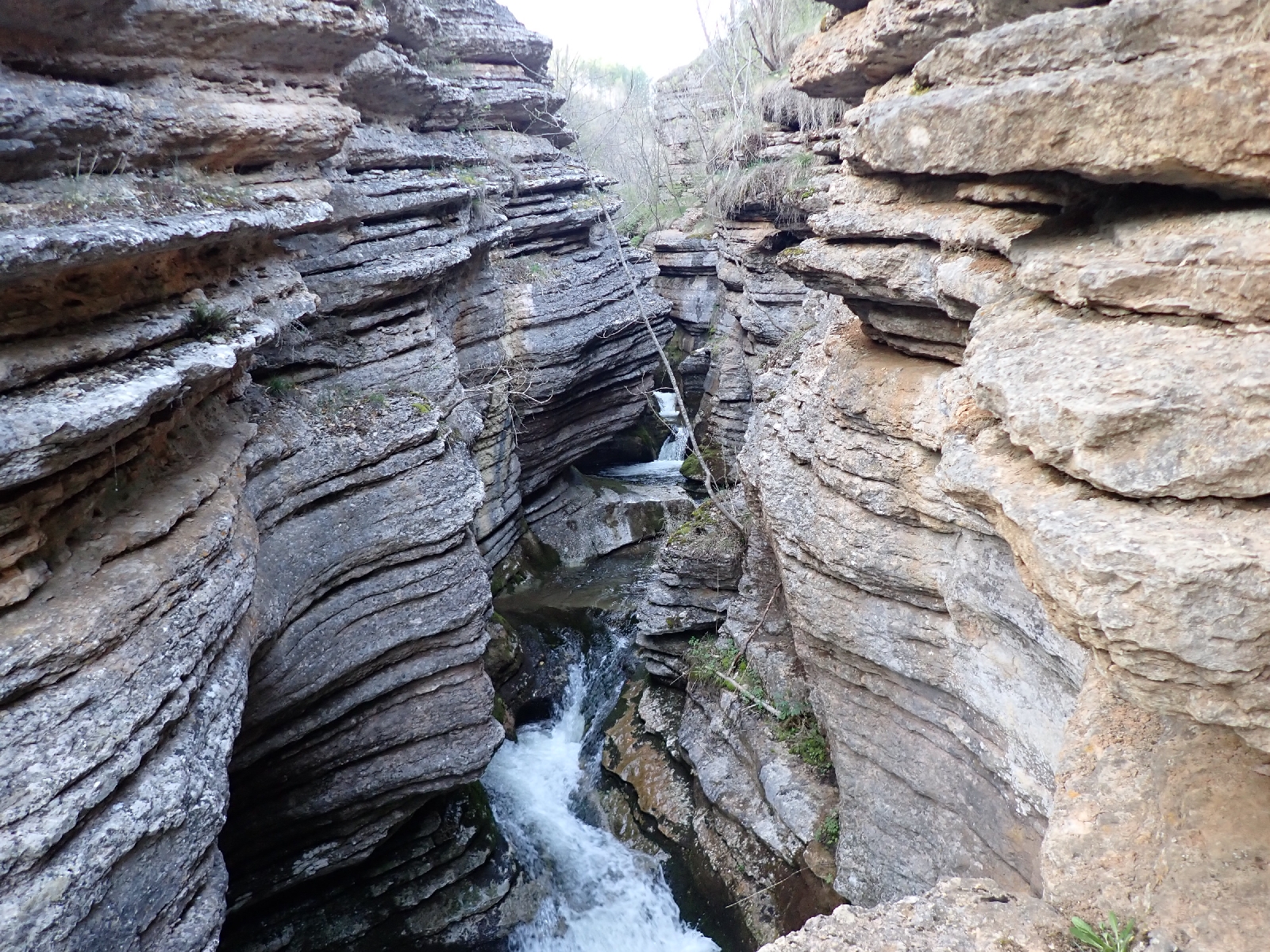
The climb up the ridge was long and so was the descent the other side. The track switched direction several times as it worked its way down the steep, wooded slope. Eventually I reached the village of Slavinja, topping up my water at the village tap. I was aiming to camp on a grassy meadow beside a path leading to a small gorge, a local tourist attraction. First I visited the gorge where a small river had cut through layered rocks giving them the appearance of a stack of pancakes. A few families with children were picnicking there and splashing in the water. After they had left, and I had eaten my supper I erected my tent and slept undisturbed for the night.


No comments:
Post a Comment